
Tuesday, 26 April 2011
Objective
This tourism blog was created to complete task for subject ITE 3543 (Introduction to E-Learning) This blog is completely from my own not from other person. This blog actually can be use as a information blog for tourist who interested to come and feel by their own the Cameron Highland peaceful scenery. It contain about activities, introduction, interesting places, Galley and links regarding Cameron Highland that may helps them. Come To Cameron Highland, Visit Malaysia.

Saturday, 16 April 2011
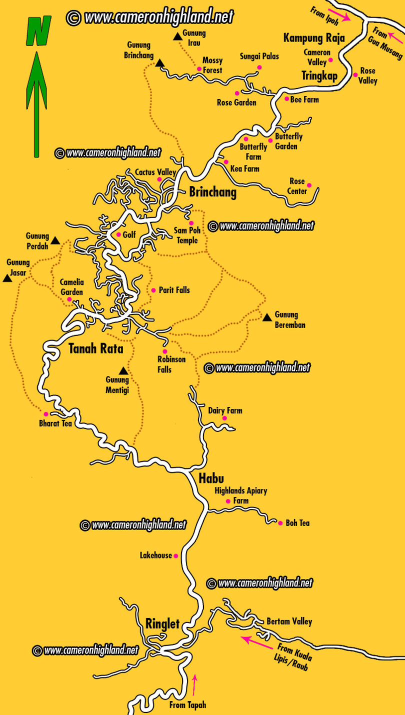
MAP
The tourist map below shows Cameron Highlands as a stretch of towns connected by a main road that starts from Ringlet, going through Tanah Rata, the biggest town, followed by Brinchang, another popular tourist spot, before finally ending all the way down to Kampung Raja after Tringkap and Kuala Terla. The main road then forks into two opposite directions heading either to Ipoh (Simpang Pulai) or Kelantan (Gua Musang). Attractions and places of interest are marked by pink spots on the map. Visitors will hopefully find this map useful for a quick and general guide to travel and explore Cameron Highlands, or to plan their route for the holiday.
 |
| click image |
Thursday, 14 April 2011
CAMERON HIGHLAND IS ONE OF MALAYSIA

The Cameron Highlands is one of Malaysia’s most extensive hill stations. It covers an area of 712 square kilometres.To the north, its boundary touches that of Kelantan to the west, it shares part of its border with Perak.
Situated at the north-western tip of Pahang, the “Camerons” is approximately 85 kilometres from Ipoh or about 200 kilometres from Kuala Lumpur.During the day, the temperature seldom soars above 25°C, at night, it is the opposite the temperature can sometimes drop to as low as 12°C.
The resort has a diverse population of more than 34,000 people. It comprises Malays, Chinese, Indians and other ethnic groups. The literacy rate here is above 88 per cent.
In all, the retreat consists of eight neighbourhoods. The three townships are Ringlet, Tanah Rata and Brinchang. The area's five settlements are the Bertam Valley, Kea Farm, Tringkap, Kuala Terla and Kampung Raja. All are nestled at an altitude of more than 1,200 meters.
The gateway to the highlands is via Tapah or Simpang Pulai. Both approaches are in the state of Perak.
BACKGROUND
The Cameron Highlands got its name from William Cameron, a British surveyor who was commissioned by the then colonial government to map out the area in 1885.He (William Cameron) mapped out the high tableland on the Perak-Pahang borders known since as the Cameron Highlands and used to return to Kuala Lumpur at unpredictable intervals bringing samples of unexploited mineral deposits.
When approached, the late Sir Hugh Low, the Resident of Perak, expressed the wish of developing the flat terrain as a “sanatorium, health resort and open farmland”. A narrow path to “Cameron’s Land” was then carved through the dense jungle. Nothing much happened after that.
Forty year later, Sir George Maxwell visited the locale and decided to transform the place into a hill station. A development committee was formed in 1925. Later, a road was constructed from Tapah to the highlands.
The building of the road was a challenge. The crew not only had to deal with the weather; they also had to live with the risk of being down with malaria.By the mid-1930s the resort was proving very popular for local leave. The Green Cow Tavern at the entrance to the Tallom Valley held the accolade of being the highest hotel in the peninsular.
When the road was completed in 1931, the British and the locals moved in to settle on the slopes of the mountain. They were soon followed by tea planters and vegetable growers who found the fertile soil and cool climate to be especially suitable for the growing of their crops.
By the mid-1930s, there was a remarkable change in the territory it now had a nine-hole golf course, several cottages, three inns, a police post, two boarding schools, a dairy, nurseries,
The district continued to grow until the outbreak of the Second World War. During the Japanese Occupation (1942–1945), there was hardly any development in the area. When the Japanese withdrew in August 1945, the place underwent a transformation.Today, the haven is not only the biggest and best known of Malaysia’s hill stations, it is also the highest point in Malaysia which is accessible by car.
 |

INTRODUCTION
Cameron Highlands is one of the most popular highlands retreat around Malaysia losing out only to Genting Highlands. With about 300,000 visitors yearly and growing, it stands to pass that Cameron Highlands has a charm of its own with its Tudor architecture style buildings, tea plantation with its soothing greenery and breathtaking scenery.
Of course with its growing popularity, it is not without its downside like traffic congestion and degradation of its pristine environment. All this and the less than efficient authorities who need to really buck up and do something about it to ensure that Cameron Highlands growing popularity will not be its own downfall.
Traveling to the highlands is different from going to the beautiful sun, sea and sand of which Malaysia has many good ones around, especially the Terengganu and Sabah beaches which are to my opinion some of the best around in Malaysia. But the tropic is indeed hot, and to cool oneself without using artificial means is of course, to travel to the highlands! With the natural environment one can commune with nature and perhaps find your center as you balance the yin and yang of a hectic hustle and bustle city lifestyle.


